The Honey War: The Legend of the Battle over a State Line
Cynthia C. Perkins
Northwest Missouri State University
Missouri History
33620
July 3, 2014
Abstract
Most disputes are usually simple misunderstandings, as is with this misunderstanding. I have come across a nearly lost local story that almost no one knows much of the details about. During Governor Boggs rein as governor of Missouri there was a dispute about the northern border between Missouri and Iowa. A story of an overzealous tax collector cutting down honey trees for taxes owed, resulting in jail time, and a near militia action. As part of my preliminary investigation into the historical significance of this event, I was able to learn about several circumstances and conditions that led up to militia action, a war of sorts. And a continuing question over the issue of the border line between Missouri and Iowa. Eventually there was a court case that moved to the United States Supreme Court to have a final decision made about the state line at a survey line.
Keywords: border dispute, honey war, taxation
The Honey War: The Legend of the Battle over a State Line
Storytelling is the conveying of events in words, and images, often by improvisation or embellishment. Stories have been shared in every culture as a means of entertainment, education, cultural preservation, and instilling moral values. Crucial elements of stories and storytelling include plot, characters, and narrative point of view. The tribes of North America, African Americans, Anglo Americans, and other cultures have all learned to pass histories and laws through rote, song and learning and through the art of storytelling. While in high school I had the opportunity to learn more about this culturally embedded art. My district invited Dr. Jester Hairston to direct our high school choirs. I learned much about slavery from a man who was two generations removed from slavery, but still had built a memory of the effects of that time in history. He taught by rote slave music, and stories of his ancestry.
This brings me to the subject of my paper, to which I have chosen to write about, and that is still remembered today through stories told. The Honey War entails stories and artifacts about a time in history that Missourians almost went to war with their neighbors over the northern border of the state.[1]
The Beginnings
From our textbook, Mark Twain’s character Tom Sawyer scolded Huckleberry Finn for thinking about states being different color on the map or different colors. Huck knew the purpose of a map. He understood boundaries of states. Missouri’s current total square area is approximately 69, 686 square miles, on the eastern boundary of the states in the Mississippi River, and the Kansas/Missouri River on the west, and the corresponding Indian line, and the southern border runs along the 36th degree latitude and the intersection of the Indian line east latitude to the middle of the Des Moines River.[2]
In 1816, J.C. Sullivan, on orders from the US Government surveyed the northern latitude of Missouri. This line was called the Indian boundary line or the Sullivan line.[3] In 1816, there was a quiet dispute of the Indian boundary line. Iowa and the Osage Native Americans made a claim that the line went too far to the north.
Sullivan Survey Line[4]
Congress passed an act describing the boundary line for the State of Missouri and the Territory of Iowa. Another surveyor, Joseph Brown, surveyed the land in 1823, and then again in 1836. He resurveyed the Sullivan line.[5] In 1836, William Clark negotiated with the Osage Indians to purchase the northwest area under the Platte Purchase. This purchase added 3,149 square miles to the area of Missouri, and it created six counties which are Platte, Buchanan, Andrew, Holt, Nodaway, and Atchison.[6]
Key Historical Figures
Some of the key figures in this whole story of the border dispute have interesting historical stories themselves. Little is known of John C. Sullivan who originally surveyed the border between Iowa and Missouri. He surveyed many other states and territorial areas. The next surveyor hired by the United States government was Joseph Brown. He surveyed and resurveyed the area.[7] Brown was born in Virginia in 1784. He came to Missouri on horseback at the end of the War of 1812. He settled in St. Louis area. He was tall, strong and well-educated, versed in surveying.[8] He dressed like a mountain man in buckskins, as picture below. He also surveyed the Southern border of the state. Like most people of this era there is little know about their personal lives.

In the archival vault of the Missouri Department of Natural Resources’ Division of Geology and Land Survey at Rolla, Missouri, is housed documents and equipment from the early surveyors.[10]

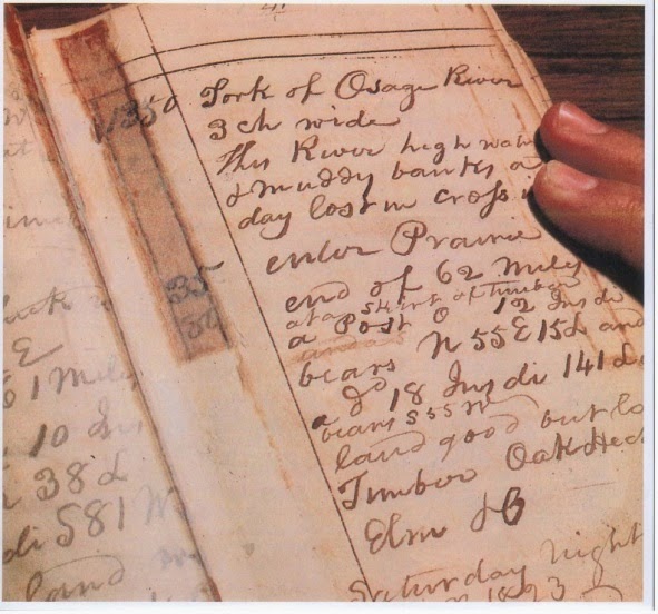
Survey books[11]
The books have the descriptions in the surveyors own handwriting. Above is a picture (number 11) of the survey books that are in the vault. Robert Myers, program director of the department’s land survey program said, “Our archival records represent more than 175 years of Missouri land survey history.”[12] He then goes on to say, “The original field notebooks of all the early surveyors are laboriously handwritten accounts form the days before the invention of fountain pens when ink was carried in a bottle. The accounts are bound by volume. Our set of original public land survey records cover the period 1815 to 1855 and there are more than 600 volumes.”[13] (See picture below, number 14)
Original handwriting in documents[14]
This vault has an electronic controlled system to protect the documents. The article mentions that the temperatures and humidity are kept steady and the vault keeps out the air particulates. This vault also houses the other equipment such as this surveyor compass, as shown in the pictures below.

Surveyor compass[15]
An important character of the Honey War is Governor Boggs, a very busy man at this time. Not only did Boggs sign the extermination order for the Mormons in Missouri he also was busy with causing turmoil leading up to the Honey War. Boggs hotly disputed the line with Governor Lucas of Iowa. He was “aroused to wrath” in August of 1839, he issued a counter proclamation refusing to cooperate with Iowa when it came to the boundary line. He wanted the area assessed for the property taxes and Iowa claimed this action was an encroachment by Missouri.[16]
Governor Lucas was the governor of Iowa and disputed Missouri’s claim on the land north of the Sullivan line. In his second annual message to the Legislative Assembly in November 1839, Lucas said that the dispute might ultimately lead to the effusion of blood.[17]
Sheriff Gregory was a sheriff for Clark County, Missouri. He was also known as “Sandy”. He entered the disputed area for the purpose of collecting taxes for Missouri. He was warned not to return.[18]
Sherriff Heffleman was sheriff of Van Buren County, Iowa. He wrote to Governor Lucas for advice and was instructed to use his own judgment with enforcement of the laws.[19]
John I. Campbell, a local satirist, was inspired by the events that transpired and he wrote a poem to which many people sang to the tune of Yankee Doodle. The poem goes as follows:[20]
The Honey War
Ye freemen of the happy land,
Which flows with milk and honey,
Arise! To arms! Your ponies mount!
Regard not blood or money.
Old Governor Lucas, tiger-like,
Is prowling around our borders,
But Governor Boggs is wide awake-
Just listening to his orders.
Three bee-trees stand about the line
Between our State and Lucas,
Be ready all these trees to fall,
And bring things to a focus.
We’ll show old Lucas how to brag,
And seize our precious honey!
He also claims, I understand,
Of us three bits in money.
Now, if the Governors want to fight,
Just let them meet in person.
And when noble Boggs old Lucas flogs,
‘Twill teach the scamp a lesson.
Then let the victor cut the trees,
And have three-bits in money,
And wear a crown from town to town.
Anointed with pure honey.
Now there were many other people involved in this conflict, but these are the key individuals involved. The United States Government also got involved at this time, as well as a Supreme Court judge who made a ruling to have a resurveying.
The Honey War
The Honey War as it was labeled was a dispute between Iowa and Missouri over the surveyed land separating the two areas. Iowa was a territory and Missouri had just become a state. Missouri wanted the area above the Sullivan survey line, thinking that area belonged to Missouri to pay taxes. The Iowans did not want to be part of Missouri and pay taxes to that state. At this time many settlers were moving into the area of southeastern Iowa and northeastern Missouri. The line was resurveyed in 1837 by J. Brown. His survey was a few miles off from the original line. In late 1838, the “Brown line” was used as the state boundary. The description was different than in the Missouri State Constitution. In 1838, the United States Government appointed a commissioner to determine the true boundary line. Governor Boggs of Missouri refused to cooperate with the commissioner and nothing was settled. By the middle of 1839, trouble started to arise when Missouri officials came into the area to assess the property for taxation purposes. They complained to Governor Lucas and he was quick to answer to the situation. July 1839, he issued a proclamation calling on all officials to uphold the territorial laws. They were to maintain the jurisdiction of the United States against encroachments. Meanwhile Boggs was “aroused to wrath” and in August 1839 he issued a counter proclamation and Missouri officials were to use their full force, and then a month later Lucas denied the counterclaims. Encouraged by the proclamations the local officials on both sides of the border executed the orders or proclamations.
In October 1839, Uriah S. Gregory of Missouri went to the disputed area for the purpose of collecting the taxes. He failed and was told to never return. In Lucas’ speech to the Legislature he mentioned that the dispute might “ultimately lead to the effusion of blood.” The climax of the whole situation was that there were three honey trees that were cut down for the assessment of the taxes that Missouri felt was owed to them. The Iowa sheriff sought to arrest the offender but they made it safely across the border. Not long after the trees were cut down the Iowa sheriff arrested the Missouri sheriff. This signaled the generals Willock and Allen to muster a militia to assist the civil authorities with maintaining the jurisdiction in the area. There are accounts that the number of troops that were assembled varies from six hundred to twenty-five hundred. There was an issue with the military at this time. There were not tents, blankets, and very little armament, and it was December with snow on the ground.
On the Iowa side they had the same issues, only the marshal immediately made a request for money to help muster a militia. Of course there was no money for the militia. In the expectation of receiving pay from the government, they gathered together a militia. To keep the spirits of the men elevated the commanders filled wagons of supplies with whiskey. The men brought their own guns and swords to fight with, and many of these were antiques. Iowa’s army consisted of about twelve hundred men. Iowa law makers requested that Governors Bogs and Lucas suspend their hostilities until United States Congress made a decision as to where the border line was.
When news that the militia was not needed, the Missouri militia decided to express their rage by dividing a deer/venison and labeling each half “Gov. Lucas of Iowa and Gov. Boggs of Missouri”. The deer was then hung up and used for target practice. The carcass were riddled with bullets, then taken down and buried in a mock military funeral. There was one account I found that reported that the animal was a pig.[21]/[22]/[23]
The two States argued over the border until the Supreme Court settled the matter. Stated in the court case decision:
“We are therefore of opinion that the northern boundary of Missouri is the Osage line, as run by Sullivan in 1816, from the northwest corner made by him to the Des Moines River; and that a line extended due west from said northwest corner to the Missouri River is the proper northern boundary on that end of the line. And this is the unanimous opinion of all the judges of this Court. Decree On this 13th day of February, A.D. 1849, the cause of the State of Missouri against the State of Iowa, on an original bill, and also on a cross-bill of the State of Iowa against the State of Missouri, constituting part of said cause, came on to be heard before the honorable the judges of the Supreme Court of the United States in open court, all of the judges of said court being present. And said cause was heard on the original bill and the answer thereto and the replication to said answer, and also on said cross-bill and the answer thereto and the replication to said answer and on the proofs in said cause, consisting of depositions, documents, and historical evidences, when it appeared to the Court that in the year 1816 the United States caused to be run and marked two lines, as part of a boundary between the United States and the Great and Little Osage nations of Indians in execution of a treaty made with said Osages in 1808… by "R. B. TANEY" "Chief Justice of Supreme Court of U.S." "Baltimore, April 6, 1849".[24]
Iron Markers
Henry Hendershot of Iowa and Robert Wells were appointed to find and resurvey the Sullivan line and place iron pillars along the border. They were to say Iowa on one side, Missouri on the opposite and state line on the other sides. The markers were to be place at ten mile intervals. The cost of the project was to be divided between the two states. Finally, in 1850 the markers were placed.[25]


The above pictures were taken at the western most end of the Sullivan line and the original spot before the Platte Purchase.[26] They show the titles of Missouri, State Line, and Iowa. They were facing in the proper directions pertaining to the direction they are facing. In other words the Missouri side is facing the direction towards Missouri. The State Line faces East and West. And the Iowa side faces Iowa.
Modern Surveying
The original markings in 1816, and in 1837, were cut into trees and different markings like stakes, and then came the iron markers in 1850. Now using modern technology, Midland Surveying was selected to resurvey the Sullivan Line and find the iron markers. Midland researched where the iron markers were to be located, and then they started the field work. They found the markers in terrible shape. Some were knocked down and with overgrowth covering them. Still, others were buried, one was six feet below where silt covered the marker and a road was now located. They were able to locate thirteen of the fifteen markers. They were also able to confirm the destruction or removal of the other two.[27] In 1989, a historical society placed at the corner of the Platte Purchase, and the Sullivan line. The plaque mentions the iron marker as a remnant of the Honey War, and that it was placed in 1850 to identify the northwest corner of the Missouri territory as determined by the Sullivan line.[28]
 Plaque placed in 1989[29]

Map of the Platte Purchase area.[30]
The above map shows the area of the boundaries before the Platte Purchase. The area in red is the land that was acquired through the purchase. At the corner of the red and the white in Worth County is where the monument and the marker are located.
 Pictured are both the plaque and the iron marker.[31]
While researching this subject, I decided to take an adventure to find the markers that were located nearby. I looked for clues as to where the markers were located, asked questions of several people. No one knew exactly where it was located. So back to the internet for more research, and estimated approximately where it was located. So after more research, we had a heading, and so kidnapping my husband for the trip, we went for an adventure. The markers are north of Sheridan, Missouri. I knew the markers are located on a gravel road on the border. At one time the markers had road on both sides of the markers. Since then the Iowa side of the road has overgrown, but the Missouri side is still maintained. The first road that we drove down was dirt! I was very glad I drove my Jeep.
 [32]
[32]
The road was a little rough. From my estimation it was to be about four miles down the road. We drove six miles and couldn’t find it, turned around and started back. Then suddenly it popped out! We drove right past it. The markers were overgrown with grass, and that is why I did not see it. The trip back was a different way and it was a nice gravel road and would be easily passible for any car.
Google Maps[33]
Even though this conflict was centered on the eastern side of the state, many Missourians still tell the stories of this conflict as if it happened yesterday and in their own backyard. These stories intrigued me as a beekeeper, due to the collection of honey to pay taxes. As a beekeeper, anything having to do with bees and honey production interests me. The collection of honey trees for payment in kind or trade and barter was a form of payment fascinates me. I have done things with my honey, such as trading eggs for the honey. This research paper has been an adventure to learn more about a piece of Missouri history that seems legendary for most local people.
Now, I am part of this Honey War Story through my own research, personal brand of storytelling and my adventuring to find the local markers that settled the almost all-out war and broken pride over our State Line with Iowa, and a few buckets of honey.
Bibliography
Eriksson, E., The Honey War. The Palimpsest, 1924.
Hayes, T. (2006). Missouri/Iowa Boundary Line. The American Surveyor.
Hill, C., The Honey War. Pioneer America. Vol.14, No.2. 1982.
Justia US Supreme Court. Taney, Chief Justice of Supreme Court of U.S. Baltimore, 1849. http://supreme.justia.com/cases/federal/us/48/660/case.html. Accessed June 20, 2014.
Lawing, T., In 1939 Missouri and Iowa came close to war with each other. Hopkins Journal, 1985.
Parrish, William E., Charles T. Jones, Jr., and Lawrence O. Christensen. Missouri, the Heart of the Nation. 3rd ed. Wheeling, IL: Wiley-Blackwell, 2004.
Perkins, C. Journalized personal memories of Dr. Jester Hairston, 1985.
Weaver, D. Setting the cornerstones of Missouri: 1815 – 1989, 1989.
University of Missouri Digital Library.
http://digital.library.umsystem.edu/cgi/t/text/pageviewer-idx?c=mocon;cc=mocon;sid=0e66c04c8bdd3e6be1bf9a401749277b;rgn=full%20text;idno=mocon000027;view=image;seq=1. Retrieved June 15, 2014.
Pictures:
Google Maps. https://www.google.com/maps/place/40%C2%B034%2715.9%22N+94%C2%B036%2702.2%22W/@40.571094,-94.600624,1209m/data=!3m1!1e3!4m2!3m1!1s0x0:0x0
Map of the Platte Purchase area. http://en.wikipedia.org/wiki/Platte_Purchase., Retrieved June 30, 2014.
Perkins, C., Pictures personally taken of the markers and plaque, Taken June 9, 2014.
Sullivan Survey Line photo. http://en.wikipedia.org/wiki/Honey_War, Retrieved June 10, 2014.
Wiki Media Commons. http://commons.wikimedia.org/wiki/File:Missouri_territory.png, Retrieved June 10, 2014.
[1] Perkins, C., Personal Journalized Memories of Dr. Jester Hairston (1985).
[2] William E. Parrish et al., Missouri, the Heart of the Nation, 3rd ed. (Wheeling, IL: Wiley-Blackwell, 2004), 1.
[3] University of Missouri Digital Library. http://digital.library.umsystem.edu/cgi/t/text/pageviewer-idx?c=mocon;cc=mocon;sid=0e66c04c8bdd3e6be1bf9a401749277b;rgn=full%20text;idno=mocon000027;view=image;seq=1. Retrieved June 15, 2014.
[4] Sullivan Survey Line photo. http://en.wikipedia.org/wiki/Honey_War . Retrieved June 10, 2014.
[5] Eriksson, E., The Honey War. The Palimpsest, 1924.
[6] William E. Parrish et al., Missouri, the Heart of the Nation, 3rd ed. (Wheeling, IL: Wiley-Blackwell, 2004), 95.
[7] Eriksson, E., The Honey War. The Palimpsest, 1924.
[8] Weaver, D., Setting the cornerstones of Missouri: 1815 – 1989, 7.
[9] Weaver, D., Setting the cornerstones of Missouri: 1815 – 1989, 8.
[10] Weaver, D., Setting the cornerstones of Missouri: 1815 – 1989, 8.
[11] Weaver, D., Setting the cornerstones of Missouri: 1815 – 1989, 6.
[12] Weaver, D., Setting the cornerstones of Missouri: 1815 – 1989, 6.
[13] Weaver, D., Setting the cornerstones of Missouri: 1815 – 1989, 6.
[14] Weaver, D., Setting the cornerstones of Missouri: 1815 – 1989, 5.
[15] Weaver, D., Setting the cornerstones of Missouri: 1815 – 1989, 4.
[16] Eriksson, E., The Honey War. The Palimpsest, 1924.
[17] Eriksson, E., The Honey War. The Palimpsest, 1924.
[18] Eriksson, E., The Honey War. The Palimpsest, 1924.
[19] Eriksson, E., The Honey War. The Palimpsest, 1924.
[20] Eriksson, E., The Honey War. The Palimpsest, 1924.
[21] Eriksson, E., The Honey War. The Palimpsest, 1924.
[22] Hill, C. (1982). The Honey War. Pioneer America. Vol.14, No.2. Pages 81 – 88
[23] Lawing, T., In 1939 Missouri and Iowa came close to war with each other. Hopkins Journal September 11, 1985.
[24] Justia US Supreme Court. Taney, Chief Justice of Supreme Court of U.S. Baltimore, 1849. http://supreme.justia.com/cases/federal/us/48/660/case.html, retrieved June 20, 2014.
[25] Hill, C., The Honey War. Pioneer America. Vol.14, No.2. 81 – 88, 1982.
[26] Perkins, C., Pictures personally taken of the markers and plaque, June 16, 2014.
[27] Hayes, T., Missouri/Iowa Boundary Line. The American Surveyor. March/April, 2006.
[28] Perkins, C., Pictures personally taken of the markers and plaque, June 16, 2014.
[29] Perkins, C., Pictures personally taken of the markers and plaque, June 16, 2014.
[30] Map of the Platte Purchase area. http://en.wikipedia.org/wiki/Platte_Purchase Retrieved June 30, 2014.
[31] Perkins, C., Pictures personally taken of the markers and plaque, June 16, 2014.
[32] Perkins, C., Pictures personally taken of the markers and plaque, June 16, 2014.
[33] Google Maps, https://www.google.com/maps/place/40%C2%B034%2715.9%22N+94%C2%B036%2702.2%22W/@40.571094,-94.600624,1209m/data=!3m1!1e3!4m2!3m1!1s0x0:0x0, Retrieved June 30, 2014.
An important character of the Honey War is Governor Boggs, a very busy man at this time. Not only did Boggs sign the extermination order for the Mormons in Missouri he also was busy with causing turmoil leading up to the Honey War. Boggs hotly disputed the line with Governor Lucas of Iowa. He was “aroused to wrath” in August of 1839, he issued a counter proclamation refusing to cooperate with Iowa when it came to the boundary line. He wanted the area assessed for the property taxes and Iowa claimed this action was an encroachment by Missouri.[16]
Governor Lucas was the governor of Iowa and disputed Missouri’s claim on the land north of the Sullivan line. In his second annual message to the Legislative Assembly in November 1839, Lucas said that the dispute might ultimately lead to the effusion of blood.[17]
Sheriff Gregory was a sheriff for Clark County, Missouri. He was also known as “Sandy”. He entered the disputed area for the purpose of collecting taxes for Missouri. He was warned not to return.[18]
Sherriff Heffleman was sheriff of Van Buren County, Iowa. He wrote to Governor Lucas for advice and was instructed to use his own judgment with enforcement of the laws.[19]
John I. Campbell, a local satirist, was inspired by the events that transpired and he wrote a poem to which many people sang to the tune of Yankee Doodle. The poem goes as follows:[20]
The Honey War
Ye freemen of the happy land,
Which flows with milk and honey,
Arise! To arms! Your ponies mount!
Regard not blood or money.
Old Governor Lucas, tiger-like,
Is prowling around our borders,
But Governor Boggs is wide awake-
Just listening to his orders.
Three bee-trees stand about the line
Between our State and Lucas,
Be ready all these trees to fall,
And bring things to a focus.
We’ll show old Lucas how to brag,
And seize our precious honey!
He also claims, I understand,
Of us three bits in money.
Now, if the Governors want to fight,
Just let them meet in person.
And when noble Boggs old Lucas flogs,
‘Twill teach the scamp a lesson.
Then let the victor cut the trees,
And have three-bits in money,
And wear a crown from town to town.
Anointed with pure honey.
Now there were many other people involved in this conflict, but these are the key individuals involved. The United States Government also got involved at this time, as well as a Supreme Court judge who made a ruling to have a resurveying.
The Honey War
The Honey War as it was labeled was a dispute between Iowa and Missouri over the surveyed land separating the two areas. Iowa was a territory and Missouri had just become a state. Missouri wanted the area above the Sullivan survey line, thinking that area belonged to Missouri to pay taxes. The Iowans did not want to be part of Missouri and pay taxes to that state. At this time many settlers were moving into the area of southeastern Iowa and northeastern Missouri. The line was resurveyed in 1837 by J. Brown. His survey was a few miles off from the original line. In late 1838, the “Brown line” was used as the state boundary. The description was different than in the Missouri State Constitution. In 1838, the United States Government appointed a commissioner to determine the true boundary line. Governor Boggs of Missouri refused to cooperate with the commissioner and nothing was settled. By the middle of 1839, trouble started to arise when Missouri officials came into the area to assess the property for taxation purposes. They complained to Governor Lucas and he was quick to answer to the situation. July 1839, he issued a proclamation calling on all officials to uphold the territorial laws. They were to maintain the jurisdiction of the United States against encroachments. Meanwhile Boggs was “aroused to wrath” and in August 1839 he issued a counter proclamation and Missouri officials were to use their full force, and then a month later Lucas denied the counterclaims. Encouraged by the proclamations the local officials on both sides of the border executed the orders or proclamations.
In October 1839, Uriah S. Gregory of Missouri went to the disputed area for the purpose of collecting the taxes. He failed and was told to never return. In Lucas’ speech to the Legislature he mentioned that the dispute might “ultimately lead to the effusion of blood.” The climax of the whole situation was that there were three honey trees that were cut down for the assessment of the taxes that Missouri felt was owed to them. The Iowa sheriff sought to arrest the offender but they made it safely across the border. Not long after the trees were cut down the Iowa sheriff arrested the Missouri sheriff. This signaled the generals Willock and Allen to muster a militia to assist the civil authorities with maintaining the jurisdiction in the area. There are accounts that the number of troops that were assembled varies from six hundred to twenty-five hundred. There was an issue with the military at this time. There were not tents, blankets, and very little armament, and it was December with snow on the ground.
On the Iowa side they had the same issues, only the marshal immediately made a request for money to help muster a militia. Of course there was no money for the militia. In the expectation of receiving pay from the government, they gathered together a militia. To keep the spirits of the men elevated the commanders filled wagons of supplies with whiskey. The men brought their own guns and swords to fight with, and many of these were antiques. Iowa’s army consisted of about twelve hundred men. Iowa law makers requested that Governors Bogs and Lucas suspend their hostilities until United States Congress made a decision as to where the border line was.
When news that the militia was not needed, the Missouri militia decided to express their rage by dividing a deer/venison and labeling each half “Gov. Lucas of Iowa and Gov. Boggs of Missouri”. The deer was then hung up and used for target practice. The carcass were riddled with bullets, then taken down and buried in a mock military funeral. There was one account I found that reported that the animal was a pig.[21]/[22]/[23]
The two States argued over the border until the Supreme Court settled the matter. Stated in the court case decision:
“We are therefore of opinion that the northern boundary of Missouri is the Osage line, as run by Sullivan in 1816, from the northwest corner made by him to the Des Moines River; and that a line extended due west from said northwest corner to the Missouri River is the proper northern boundary on that end of the line. And this is the unanimous opinion of all the judges of this Court. Decree On this 13th day of February, A.D. 1849, the cause of the State of Missouri against the State of Iowa, on an original bill, and also on a cross-bill of the State of Iowa against the State of Missouri, constituting part of said cause, came on to be heard before the honorable the judges of the Supreme Court of the United States in open court, all of the judges of said court being present. And said cause was heard on the original bill and the answer thereto and the replication to said answer, and also on said cross-bill and the answer thereto and the replication to said answer and on the proofs in said cause, consisting of depositions, documents, and historical evidences, when it appeared to the Court that in the year 1816 the United States caused to be run and marked two lines, as part of a boundary between the United States and the Great and Little Osage nations of Indians in execution of a treaty made with said Osages in 1808… by "R. B. TANEY" "Chief Justice of Supreme Court of U.S." "Baltimore, April 6, 1849".[24]
Iron Markers
Henry Hendershot of Iowa and Robert Wells were appointed to find and resurvey the Sullivan line and place iron pillars along the border. They were to say Iowa on one side, Missouri on the opposite and state line on the other sides. The markers were to be place at ten mile intervals. The cost of the project was to be divided between the two states. Finally, in 1850 the markers were placed.[25]
The above pictures were taken at the western most end of the Sullivan line and the original spot before the Platte Purchase.[26] They show the titles of Missouri, State Line, and Iowa. They were facing in the proper directions pertaining to the direction they are facing. In other words the Missouri side is facing the direction towards Missouri. The State Line faces East and West. And the Iowa side faces Iowa.
Modern Surveying
The original markings in 1816, and in 1837, were cut into trees and different markings like stakes, and then came the iron markers in 1850. Now using modern technology, Midland Surveying was selected to resurvey the Sullivan Line and find the iron markers. Midland researched where the iron markers were to be located, and then they started the field work. They found the markers in terrible shape. Some were knocked down and with overgrowth covering them. Still, others were buried, one was six feet below where silt covered the marker and a road was now located. They were able to locate thirteen of the fifteen markers. They were also able to confirm the destruction or removal of the other two.[27] In 1989, a historical society placed at the corner of the Platte Purchase, and the Sullivan line. The plaque mentions the iron marker as a remnant of the Honey War, and that it was placed in 1850 to identify the northwest corner of the Missouri territory as determined by the Sullivan line.[28]
Map of the Platte Purchase area.[30]
The above map shows the area of the boundaries before the Platte Purchase. The area in red is the land that was acquired through the purchase. At the corner of the red and the white in Worth County is where the monument and the marker are located.
While researching this subject, I decided to take an adventure to find the markers that were located nearby. I looked for clues as to where the markers were located, asked questions of several people. No one knew exactly where it was located. So back to the internet for more research, and estimated approximately where it was located. So after more research, we had a heading, and so kidnapping my husband for the trip, we went for an adventure. The markers are north of Sheridan, Missouri. I knew the markers are located on a gravel road on the border. At one time the markers had road on both sides of the markers. Since then the Iowa side of the road has overgrown, but the Missouri side is still maintained. The first road that we drove down was dirt! I was very glad I drove my Jeep.
The road was a little rough. From my estimation it was to be about four miles down the road. We drove six miles and couldn’t find it, turned around and started back. Then suddenly it popped out! We drove right past it. The markers were overgrown with grass, and that is why I did not see it. The trip back was a different way and it was a nice gravel road and would be easily passible for any car.
Google Maps[33]

Even though this conflict was centered on the eastern side of the state, many Missourians still tell the stories of this conflict as if it happened yesterday and in their own backyard. These stories intrigued me as a beekeeper, due to the collection of honey to pay taxes. As a beekeeper, anything having to do with bees and honey production interests me. The collection of honey trees for payment in kind or trade and barter was a form of payment fascinates me. I have done things with my honey, such as trading eggs for the honey. This research paper has been an adventure to learn more about a piece of Missouri history that seems legendary for most local people.
Now, I am part of this Honey War Story through my own research, personal brand of storytelling and my adventuring to find the local markers that settled the almost all-out war and broken pride over our State Line with Iowa, and a few buckets of honey.
Bibliography
Eriksson, E., The Honey War. The Palimpsest, 1924.
Hayes, T. (2006). Missouri/Iowa Boundary Line. The American Surveyor.
Hill, C., The Honey War. Pioneer America. Vol.14, No.2. 1982.
Justia US Supreme Court. Taney, Chief Justice of Supreme Court of U.S. Baltimore, 1849. http://supreme.justia.com/cases/federal/us/48/660/case.html. Accessed June 20, 2014.
Lawing, T., In 1939 Missouri and Iowa came close to war with each other. Hopkins Journal, 1985.
Parrish, William E., Charles T. Jones, Jr., and Lawrence O. Christensen. Missouri, the Heart of the Nation. 3rd ed. Wheeling, IL: Wiley-Blackwell, 2004.
Perkins, C. Journalized personal memories of Dr. Jester Hairston, 1985.
Weaver, D. Setting the cornerstones of Missouri: 1815 – 1989, 1989.
University of Missouri Digital Library.
http://digital.library.umsystem.edu/cgi/t/text/pageviewer-idx?c=mocon;cc=mocon;sid=0e66c04c8bdd3e6be1bf9a401749277b;rgn=full%20text;idno=mocon000027;view=image;seq=1. Retrieved June 15, 2014.
Pictures:
Google Maps. https://www.google.com/maps/place/40%C2%B034%2715.9%22N+94%C2%B036%2702.2%22W/@40.571094,-94.600624,1209m/data=!3m1!1e3!4m2!3m1!1s0x0:0x0
Map of the Platte Purchase area. http://en.wikipedia.org/wiki/Platte_Purchase., Retrieved June 30, 2014.
Perkins, C., Pictures personally taken of the markers and plaque, Taken June 9, 2014.
Sullivan Survey Line photo. http://en.wikipedia.org/wiki/Honey_War, Retrieved June 10, 2014.
Wiki Media Commons. http://commons.wikimedia.org/wiki/File:Missouri_territory.png, Retrieved June 10, 2014.
[1] Perkins, C., Personal Journalized Memories of Dr. Jester Hairston (1985).
[2] William E. Parrish et al., Missouri, the Heart of the Nation, 3rd ed. (Wheeling, IL: Wiley-Blackwell, 2004), 1.
[3] University of Missouri Digital Library. http://digital.library.umsystem.edu/cgi/t/text/pageviewer-idx?c=mocon;cc=mocon;sid=0e66c04c8bdd3e6be1bf9a401749277b;rgn=full%20text;idno=mocon000027;view=image;seq=1. Retrieved June 15, 2014.
[4] Sullivan Survey Line photo. http://en.wikipedia.org/wiki/Honey_War . Retrieved June 10, 2014.
[5] Eriksson, E., The Honey War. The Palimpsest, 1924.
[6] William E. Parrish et al., Missouri, the Heart of the Nation, 3rd ed. (Wheeling, IL: Wiley-Blackwell, 2004), 95.
[7] Eriksson, E., The Honey War. The Palimpsest, 1924.
[8] Weaver, D., Setting the cornerstones of Missouri: 1815 – 1989, 7.
[9] Weaver, D., Setting the cornerstones of Missouri: 1815 – 1989, 8.
[10] Weaver, D., Setting the cornerstones of Missouri: 1815 – 1989, 8.
[11] Weaver, D., Setting the cornerstones of Missouri: 1815 – 1989, 6.
[12] Weaver, D., Setting the cornerstones of Missouri: 1815 – 1989, 6.
[13] Weaver, D., Setting the cornerstones of Missouri: 1815 – 1989, 6.
[14] Weaver, D., Setting the cornerstones of Missouri: 1815 – 1989, 5.
[15] Weaver, D., Setting the cornerstones of Missouri: 1815 – 1989, 4.
[16] Eriksson, E., The Honey War. The Palimpsest, 1924.
[17] Eriksson, E., The Honey War. The Palimpsest, 1924.
[18] Eriksson, E., The Honey War. The Palimpsest, 1924.
[19] Eriksson, E., The Honey War. The Palimpsest, 1924.
[20] Eriksson, E., The Honey War. The Palimpsest, 1924.
[21] Eriksson, E., The Honey War. The Palimpsest, 1924.
[22] Hill, C. (1982). The Honey War. Pioneer America. Vol.14, No.2. Pages 81 – 88
[23] Lawing, T., In 1939 Missouri and Iowa came close to war with each other. Hopkins Journal September 11, 1985.
[24] Justia US Supreme Court. Taney, Chief Justice of Supreme Court of U.S. Baltimore, 1849. http://supreme.justia.com/cases/federal/us/48/660/case.html, retrieved June 20, 2014.
[25] Hill, C., The Honey War. Pioneer America. Vol.14, No.2. 81 – 88, 1982.
[26] Perkins, C., Pictures personally taken of the markers and plaque, June 16, 2014.
[27] Hayes, T., Missouri/Iowa Boundary Line. The American Surveyor. March/April, 2006.
[28] Perkins, C., Pictures personally taken of the markers and plaque, June 16, 2014.
[29] Perkins, C., Pictures personally taken of the markers and plaque, June 16, 2014.
[30] Map of the Platte Purchase area. http://en.wikipedia.org/wiki/Platte_Purchase Retrieved June 30, 2014.
[31] Perkins, C., Pictures personally taken of the markers and plaque, June 16, 2014.
[32] Perkins, C., Pictures personally taken of the markers and plaque, June 16, 2014.
[33] Google Maps, https://www.google.com/maps/place/40%C2%B034%2715.9%22N+94%C2%B036%2702.2%22W/@40.571094,-94.600624,1209m/data=!3m1!1e3!4m2!3m1!1s0x0:0x0, Retrieved June 30, 2014.